Sites of Indus Valley Civilization (Part 2)
Harappa
Harappa was the Site which changed the World View and understanding of Indian History . Earlier to the discovery of this site some Historians found out similarities between the linguistics of Indian Subcontinent and Europe and Middle East Asia , they hypothesized that a migration would have been taken place from the Pont Steppe region to Europe and South East Asia which was true according to European Historical Evidences and Discourse, but when the discovery of Harappa happened the carbon dating was found out to be much earlier than the predicted Migration, It changed the Whole discourse and disrupted the earlier hypothesis of Invasion and Migration to the Indian Sub-Continent and South East Asia. There are Debates ,Views and Different Hypothesis about the Indus Valley Civilization among Historians, but due to Discovery of this Site it was Certain that our Civilization was much older and existed much earlier.
Harappa is located at Dry River Basin of Ravi River in present day Pakistan. The Harappan Civilization has its earliest roots in cultures such as that of Mehrgarh, approximately 6000 BC. The two greatest cities, Mohenjo-daro and Harappa, emerged around 2600 BC along the Indus River valley in Punjab and Sindh. The civilization had a writing system, urban centers, and diversified social and economic system, well planned Cities and sanitation systems !!!
The Indus Valley civilization was basically an urban culture sustained by surplus agricultural production and commerce, it also included trade with Elam and Sumer in southern Mesopotamia and Egypt . Both Mohenjo-Daro and Harappa are generally characterized as having "differentiated living quarters, flat-roofed brick houses, and fortified administrative or religious centers. such similarities suggests for the existence of a standardized system of urban layout and planning.
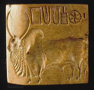
The weights and measures of the Indus Valley Civilization, on the other hand, were highly standardized, and conform to a set scale of gradations. Distinctive seals were used, among other applications, perhaps for the identification of property and shipment of goods. Copper and bronze were in used. Cotton was woven and dyed for clothing; wheat, rice, and a variety of vegetables and fruits were cultivated; and a number of animals, including the humped bull, was domesticated," as well as "fowl for fighting". Wheel-made pottery—some of it adorned with animal and geometric motifs—has been found in profusion at all the major Indus sites. A centralized administration for each city, though not the whole civilization, has been inferred from the revealed cultural uniformity. Harappans had many trade routes along the Indus River that went as far as the Persian Gulf, Mesopotamia, and Egypt. Some of the most valuable things traded were carnelian and lapis lazuli.

Kalibangan
Kalibangān is located at on the left or southern banks of the Ghaggar (Ghaggar-Hakra River) in Tehsil Pilibangān, between Suratgarh and Hanumangarh in Hanumangarh District, Rajasthan, India 205 km from Bikaner. It is also identified as being established in the triangle of land at the confluence of Drishadvati and Sarasvati Rivers.
Two ancient mounds were excavated, spread over half a kilometre (an area of a quarter square kilometre). On the western side is the smaller mound (KLB1), 9 meters high and known as the citadel. The Eastern mound, which is high .
Kalibangan in Rajasthan has given the evidence of the earliest (c. 2800 BC) ploughed agricultural field ever revealed through an excavation.It has been found south east of the pre-Harappan settlement, outside the fort. Kalibangan excavations in present western Rajasthan shows a ploughed field, the first site of this nature in the world. It shows a grid pattern of furrows, placed about 30 cm apart running east-west and other spaced about 190 cm apart running north-south, a pattern remarkably similar to the one practiced even now (12 meters) and bigger, is known as the lower city.

Lothal
Lothal was a vital and thriving trade centre in ancient times, with its trade of beads, gems and valuable ornaments reaching the far corners of West Asia and Africa. The techniques and tools they pioneered for bead-making and in metallurgy have stood the test of time for over 4000 years.
Lothal is situated near the village of Saragwala in the Dholka Taluka of Ahmedabad district.
Lothal planners engaged themselves to protect the area from consistent floods. The town was divided into blocks of 1–2-metre-high (3–6 ft) platforms of sun-dried bricks, each serving 20–30 houses of thick mud and brick walls. The city was divided into a citadel, or acropolis and a lower town. The rulers of the town lived in the acropolis, which featured paved baths, underground and surface drains (built of kiln-fired bricks) and potable water well. The lower town was subdivided into two sectors. A north-south arterial street was the main commercial area. It was flanked by shops of rich and ordinary merchants and craftsmen. The residential area was located to either side of the marketplace. The lower town was also periodically enlarged during Lothal's years of prosperity
Lothal engineers accorded high priority to the creation of a dockyard and a warehouse to serve the purposes of naval trade. While the consensus view amongst archaeologists identifies this structure as a "dockyard," it has also been suggested that owing to small dimensions, this basin may have been an irrigation tank and canal. The dock was built on the eastern flank of the town, and is regarded by archaeologists as an engineering feat of the highest order.[citation needed] It was located away from the main current of the river to avoid silting, but provided access to ships in high tide as well. The warehouse was built close to the acropolis on a 3.5-metre-high (10.5 ft) podium of mud bricks. The rulers could thus supervise the activity on the dock and warehouse simultaneously. Facilitating the movement of cargo was a mudbrick wharf, 220 metres (720 feet) long, built on the western arm of the dock, with a ramp leading to the warehouse. There was an important public building opposite to the warehouse whose superstructure has completely disappeared. Throughout their time, the city had to brace itself through multiple floods and storms. Dock and city peripheral walls were maintained efficiently.[citation needed] The town's zealous rebuilding ensured the growth and prosperity of the trade.

The uniform organisation of the town and its institutions give evidence that the Harappans were very disciplined people. Commerce and administrative duties were performed according to standards laid out. Municipal administration was strict – the width of most streets remained the same over a long time, and no encroached structures were built. Householders possessed a sump, or collection chamber to deposit solid waste in order to prevent the clogging of city drains. Drains, manholes and cesspools kept the city clean and deposited the waste in the river, which was washed out during high tide.
A new provincial style of Harappan art and painting was pioneered. The new approaches included realistic portrayals of animals in their natural surroundings. Metalware, gold and jewellery and tastefully decorated ornaments attest to the culture and prosperity of the people of Lothal.
Most of their equipment: metal tools, weights, measures, seals, earthenware and ornaments were of the uniform standard and quality found across the Indus civilization. Lothal was a major trade centre, importing en masse raw materials like copper, chert and semi-precious stones from Mohenjo-daro and Harappa, and mass distributing to inner villages and towns. It also produced large quantities of bronze celts, fish-hooks, chisels, spears and ornaments. Lothal exported its beads, gemstones, ivory and shells.
An intensive trade network gave the inhabitants great prosperity. The network stretched across the frontiers to Egypt, Bahrain and Sumer. One of the evidence of trade in Lothal is the discovery of typical Persian gulf seals, a circular button seal.

Mohenjo-Daro
Mohenjo-daro was built in the 26th century BCE. It was one of the largest cities of the ancient Indus Valley Civilization, also known as the Harappan Civilization,which developed around 3,000 BCE from the prehistoric Indus culture. At its height, the Indus Civilization spanned much of what is now Pakistan and North India
Mohenjo-daro has a planned layout with rectilinear buildings arranged on a grid plan. Most were built of fired and mortared brick; some incorporated sun-dried mud-brick and wooden superstructures. The covered area of Mohenjo-daro is estimated at 300 hectares.

The location of Mohenjo-daro was built in a relatively short period of time, with the water supply system and wells being some of the first planned constructions. With the excavations done so far, over 700 wells are present at Mohenjo-daro, alongside drainage and bathing systems. This number is unheard of when compared to other civilizations at the time, such as Egypt or Mesopotamia, and the quantity of wells transcribes as one well for every three houses. Because the large number of wells, it is believed that the inhabitants relied solely on annual rainfall, as well as the Indus River's course remaining close to the site, alongside the wells providing water for long periods of time in the case of the city coming under siege.Due to the period in which these wells were built and used, it is likely that the circular brick well design used at this and many other Harappan sites are an invention that should be credited to the Indus civilization, as there is no existing evidence of this design from Mesopotamia or Egypt at this time, and even later. Sewage and waste water for buildings at the site were disposed of via a centralized drainage system that ran alongside the site's streets.These drains that ran alongside the road were effective at allowing most human waste and sewage to be disposed of as the drains most likely took the waste toward the Indus River.

Numerous objects found in excavation include seated and standing figures, copper and stone tools, carved seals, balance-scales and weights, gold and jasper jewellery, and children's toys. Many bronze and copper pieces, such as figurines and bowls, have been recovered from the site, showing that the inhabitants of Mohenjo-daro understood how to utilize the lost wax technique.

The furnaces found at the site are believed to have been used for copperworks and melting the metals as opposed to smelting. There even seems to be an entire section of the city dedicated to shell-working, located in the northeastern part of the site. Some of the most prominent copperworks recovered from the site are the copper tablets which have examples of the untranslated Indus script and iconography. While the script has not been deciphered yet, many of the images on the tablets match another tablet and both hold the same caption in the Indus language, with the example given showing three tablets with the image of a mountain goat and the inscription on the back reading the same letters for the three tablets.

NOTE :-
This blog is meant for Educational Purpose only .We do not own any Copyrights related to images and information , all the rights goes to their respective owners . The soul purpose of this blog is to Educate, Inspire, Empower and to create awareness in the viewers. The usage is non-commercial(Not For Profit) and we do not make any money from it.


Comments
Post a Comment